Friday, April 25, 2014

Overview

Our Journey

A map and rough path of where we went each day can be seen below.

Days 1 and 5 -- Reykjavik


Day 2 -- Reykjavik to Vik


Day 3 -- Vik to Fludir


Day 4 -- Fludir to Reykjavik


Future Directions for Iceland

My mom and I both said that we would jump at the opportunity to visit Iceland again.  When thinking about what we would visit again and what wouldn't be as worthwhile, these were our thoughts:

  • We wouldn't need to spend as much time in Reykjavik (unless there was a special event)
  • Visit again: Blue Lagoon, Skogafoss for the hike past the glacier, and I thought Pingvellir 
  • Skip: Geysir and Gullfoss; they are nice to visit for first-timers since they are the "must-sees" of Iceland besides the Blue Lagoon and Pingvellir, but they were overrun by many tourists, and could be sufficiently seen in <10-20 min
  • We would also want to explore more of the areas around Vik, including eastward; some of the most beautiful landscapes are rumored to be here
  • I would want to visit the north, because there is supposed to be another natural outdoor thermal pool, and the landscape seemed majestic and beautiful from the Iceland Guidebook
  • Puffins and the Northern Lights still have yet to be checked off of the bucket list

Thank you to everyone who followed our adventures!  The blog was written in exceptional detail for my own viewing and remembrance later--hopefully it will be helpful to anyone considering traveling to Iceland in the future.  If any advice is needed, my mom and I can always be contacted, and would be happy to share our insights!

Day 5 -- Last Day in Reykjavik

My mom and I woke up relatively late again since we had already explored much of Reykjavik on Day 1.  We got our complimentary breakfast once again at the Reykjavik Lights Hotel--same food as last time for me: salami, cheese, and cucumber sandwich and some fruit.

We decided to tour a bit more of town since we weren't getting picked up by the Flybus until 1 PM.  Today is a national holiday for the first day of spring in Iceland, so hours were a little thrown off for restaurants and shops.  I wore my Icelandic sweater in anticipation of cold and wind, and of course it was neither of those.  We walked down the same strip of cute shops and cobblestone roads as on Day 1, but wanted to explore the Old Harbor more (more westward in the city).  

Bernhoftstorfa houses (left) and chessboard (right)
We came upon an older handful of houses called the Bernhoftstorfa houses, which were named after the T.D. Bernhoft bakery--the first bakery in Iceland.  All of the houses were restored to their original form after a fire in 1977.  The row of buildings that make up the Bernhoftstorfa are an important landmark for architectural history in Reykjavik.  Part of the Bernhoftstorfa houses can be seen to the left in the adjacent image, along with an open-air chessboard that was installed in 1981 near the buildings.

We then walked down to the Old Harbor and looked at all of the docked boats.  We saw an Icelandic Coast Guard small ship; my Mom said she heard that the Icelandic Coast Guard is supposed to be one of the most reputable coast guards in the world.  This wasn't too surprising after looking at all of the signs (at least a dozen) for various  shipwrecks around the coast of Iceland--whether from trying to dock on the rocky coast or from combat.

Landakotskirkja Catholic Church in Reykjavik
Finally, we needed to start heading back to our hotel; we went back a different route and found ourselves on another charming, cobblestone web of buildings and roads.  We also passed a Catholic church, which wasn't as massive and architecturally profound as the Lutheran Church we saw on Day 1;  this is likely a result of Iceland's religious history, including the period when Catholicism was outlawed under the Danish rule (around 1550).

Finally we arrived back near our hotel.  We got food from an Icelandic Chipotle-like restaurant.  I got a classic quesadilla, which had similar contents to what I would get in a burrito at Chipotle (so good!) and my mom got something similar to a burrito salad.  We then waited for and got on the Flybus back to the Keflavik International Airport.  Overall, we had a fantastic trip, and agreed that we would both eagerly return in the future!


Thursday, April 24, 2014

Day 3 -- Fludir and the Golden Circle

Mom and I made sure that we were punctual about grabbing breakfast at 7:30 AM at the Dyrholaey Hotel since we personally requested the time.  We had a similar breakfast to yesterday: salami or salmon, vegetables, and cheese sandwich.  There were also pastries, small fruits, and cereals as options.  We ate and checked-out quickly, since we had another long driving day ahead.

Solheimajokull Glacier

The word of the day for today was windy.  Right from the start, we greeted with strong wind gusts and light rain.  We drove back westward on Route 1 for less than 20 km before we saw a glacier away from the coastline.  We saw a gravel road with a sign in front advertising a glacier tour; we had no intention of doing the tour, but we knew it would be possible to get closer to the glacier, so we turned around and went down the gravel road.  We had doubts about our small car making it out and back, but we were in luck.  We got out of the car and started hiking along a trail that went towards the  glacier, but our progress was extremely slow due to the wind.  The wind was so strong at points that I couldn't hear my mom talking to me from 2 feet away; also, turning sideways to the gusts would not allow you to breathe through one nostril, and my ears ached from either the pressure gradients or noise.  We captured a few photos and then were almost literally blown back to our car.

We found out from signs at the trailhead that the glacier we saw was called Solheimajokull glacier, which is a 14 km long outlet glacier that projects down a valley from the Myradalsjokull glacier.  Due to the shape and location (it is at a lower elevation than Myradalsjokull), it is very sensitive to climate change; progress of the glacier since 1969 has shown oscillations of progressing forward and retreating down the valley over time depending on the mass balance of precipitation and the temperature.

The Myradalsjokull glacier, just north of the Solheimajokull glacier, is fascinating because it lies on top of one of Iceland's most infamous volcanos, Katla.  Katla has erupted twenty times since Iceland was settled (or roughly twice every century).  These eruptions cause large flooding due to melting of the glacier;  flood water can flow 100,000 to 300,000 meters cubed per second in a matter of hours when Katla erupts, which can have fatal consequences on the surrounding area.

Solheimajokull glacier

Skogafoss

We continued driving on Route 1 when we saw a waterfall that we had skipped yesterday in our rush to get to our hotel in time.  The waterfall is called Skogafoss, and is inside the small town of Skogar.  Legend has it that Prasi, the Viking who settled in Skogar, hid a chest of gold behind the waterfall.  The only item that has been retrieved from the treasure so far is a gold ring, which is affixed to the church door at Skogar.  From the waterfall, a hiking path follows the river up beyond Skogafoss for about 26 km, over which 23 waterfalls can be seen along the river.  At an elevation of 1040 m up along the path, a view of both the Myrdalsjokull and Eyjafjallajokull glaciers can be seen on either side.  Further, there are cliffs to traverse with chains to hold onto.  My mom and I only hiked up a mile or two at most from Skogafoss since we still had a lot of driving to do, but this hike is now on my Iceland bucket list.

Mom in front of Skogafoss


Further up the river past Skogafoss
We drove on Route 1 further and then north on Route 30, and eventually arrived at the Fludir Icelandair Hotel, which was situated in a cute town with rolling hills and a mountain backdrop further north.  We dropped our bags off in the rooms, and asked the receptionist for recommendations for lunch and interesting spots to visit near Fludir.  She pointed us in the direction of a place called Cafe Mika in Reykholt, Iceland--just slightly southwest of our current location.  We drove out and I got a pasta with vegetables in a white wine sauce dish and my mom got a cheese salad dish.  The meals turned out to be fantastic!  They certainly didn't skip out on making it aesthetically pleasing or interesting in composition; my mom even had brie in her cheese salad.  

Once we were done, we got back in the car and headed north on Route 35 and 37 to do part of the famous Golden Circle tour, which is comprised of Geysir, Gullfoss, and Pingvellir National Park.  We knew instantly when we were approaching Geysir because of the strong sulfur smell that overtook the car.

Geysir

Iceland is divided into low and high temperature geothermal zones due to the Mid-Atlantic ridge cutting the country into two parts and constantly shifting (2 cm/year, although other sources have said less by an order of magnitude). Geysir is a high temperature geothermal zone in Iceland (meaning it is within the volcanic zone), with a base temperature around 250 degrees C.  The Geysir geothermal area covers an area of 3 square kilometers.  Geysir is the second largest geyser in the world (stray height 70 - 80 m) behind Steamboat (90 - 120 m) in the U.S., and the origin of the term geyser was inspired by Geysir (the Icelandic verb "geysa" means to gush).

Strokkur geyser
A geyser's periodic ejection of hot water is due to its proximity to magma within volcanic areas.  Water deep in the ground begins to heat up when it touches the hot rocks.  As the water from various reservoirs fills the column and begins to approach the surface of the ground, the water exposed to the air is cooled by convection.  The water column collapses due to the cool water on top pushing down on the hot water deeper in the column, causing superheating of the deeper water to occur.  When steam bubbles are eventually formed and bubble up through the surface, some of the pressure is released within the column, causing the hot water to flash into steam and shoot out of the geyser.

We walked around and looked at all of the small and large bubbling pools.  The only active geyser that we saw while we were there was Strokkur, the fourth largest in the world (height of 25-35 m); Strokkur "ejected" about ever 10 min.

Gullfoss

The next destination we drove to was Gullfoss, which is further north on Route 37 and is a part of the Golden Circle tour.  There are a few theories as to how Gullfoss was named, ranging from the golden color of the waters in the evening to a legend of a farmer who selfishly threw all of his gold into the falls so no one else cold possess it.  Gullfoss was the target of potential construction to harness it's power for electricity numerous times, but each attempt was fought by individual environmentalists who had a personal connection with the waterfall.    One of these environmentalists was Sigridur Tomasdottir in Brattholt; a shrine was erected for and a trail leading to a majestic view of the waterfall was named after her for her efforts.  Gullfoss was preserved and made into a nature reserve in 1979.

Mom and I at Gullfoss
The winds we experienced at Gullfoss were the roughest that we experienced on our trip to Iceland thus far.  Since the wind was inconsistent as well as strong, it often took us by surprise and almost blew us off of the walking trail (we did not dare to get too close to the water for this reason).  When we climbed down the Sigridur trail and caught our first glimpse of the waterfall, it lived up to it's glorious reputation.  I gate getting following the waterfall and river more upstream was closed off, but my mom and I, along with the majority of the other visitors, were not extremely mindful of this.

View from the top of Gullfoss

 We also saw a shirt that pretty much summed up our experience with the Icelandic language:


We decided to save the third and final part of the Golden Circle tour, Pingvellir National Park, for the following day since it would be along the way back to Reykjavik.

Laugarvatn Fontana Thermal Pool

Laugarvatn Fontana thermal pool
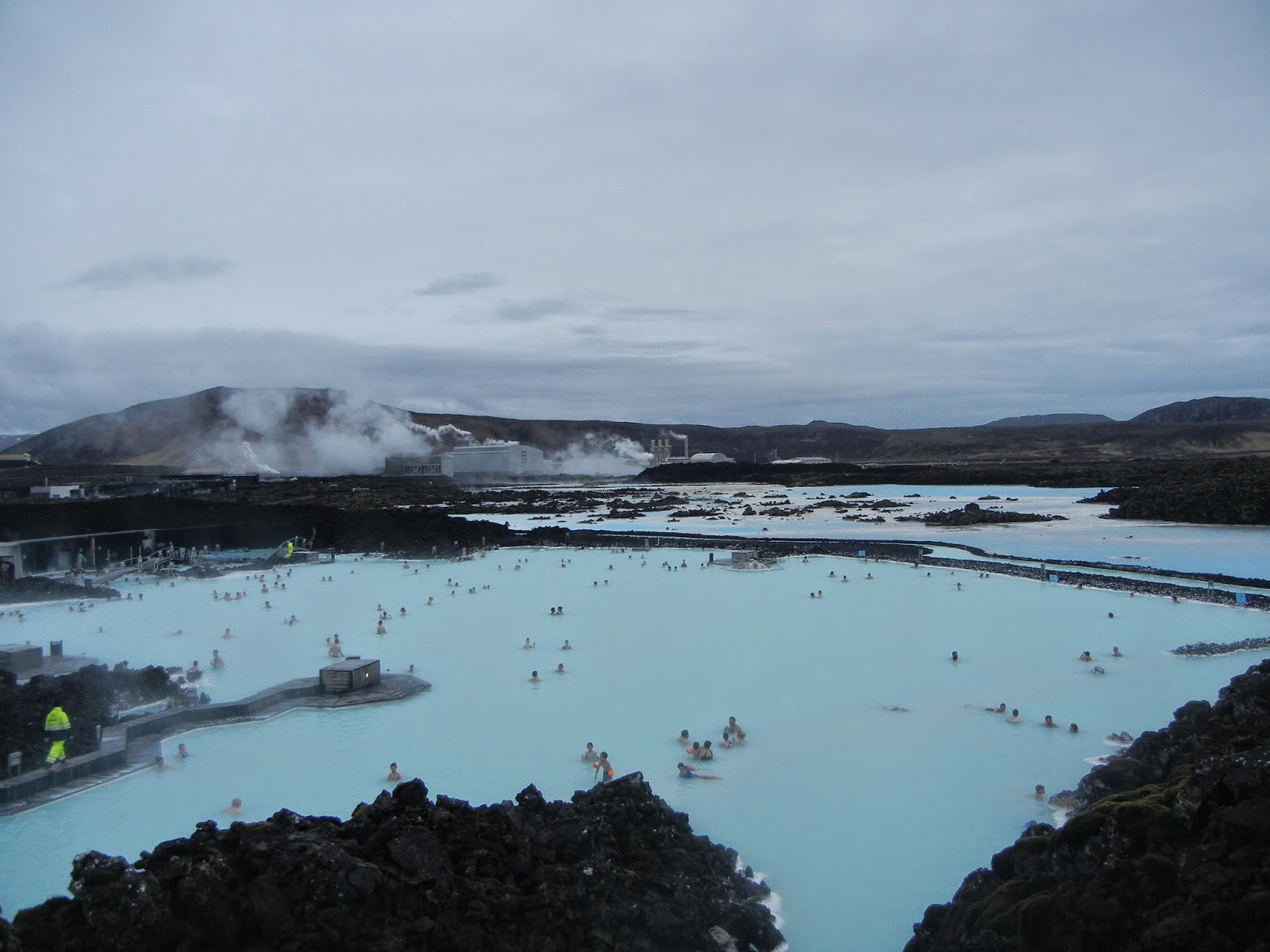
After all of the wind throughout the day, we decided that a thermal pool sounded appealing.  We stopped at a thermal pool in Laugarvatn (southwest of Geysir and Gullfoss on Route 37) called Fontana, and soaked for an hour or two.  Fontana was constructed in 2011 using one of the three, mineral-rich hot springs that are present near the shore of lake Laugarvatn.  Fontana was very different from Blue Lagoon.  Fontana didn't look natural (it looked like a normal swimming pool), which is probably why there was less of a touristy appeal.  Both experiences were unique and worthwhile in different ways.  Fontana was much more relaxing for me since we shared the pool with only six to eight other people max.  It also felt cleaner (with the exception of a lot of algae living in one of the pools), and had more structures promoting being active and moving around within the springs.  I personally enjoyed a small C-shaped structure that spurted out warm streams on three sides.  My mom and I both agreed that visiting both the Blue Lagoon and Fontana were fun and worthwhile for different experiences.

Kerio

We had one more location that we were set on visiting for the day;  Kerio, located about 30 km southwest of Laugarvatn (driving 37 South and 35 South), is a crater with a lake formed about 6,500 years ago.  It was originally believed that the crater was formed by a huge volcanic explosion, like most crater volcanos, but further studies contradicted this; it is now believed instead that Kerio was a cone volcano that erupted and emptied its magma reserve.  The crater is like a window to the groundwater since it rises and falls with the water table.


Kerio

A purple lava rock at Kerio
My mom and I hiked down to the bottom and around a footpath at the water's edge.  We found all of the colors of the lava rock very fascinating; there were vivid reds, purple, pink, orange, yellow, blue, and then mixes of all of these colors in the rocks.  We then climbed back up and walked around the top of the crater.


We drove back northwest to get to our hotel in Fludir in time for a late dinner.  We decided to eat at the hotel restaurant since we had a long day of traveling, and we weren’t anxious to walk around any more than we needed to.  I got a delicious lamb steak dish and my mom got a local cod dish.  We both were in the mood for desert afterwards.  I got a brownie with vanilla ice cream and my mom got a strawberry, creamy dessert.  The hotel had a beautiful view of the northern mountains, and I was able to watch the sun slowly set in a pink hue over the mountains as I began the blog.  Once again, I wanted to keep my eyes peeled for the northern lights, but even at 11:30 PM, there was a remaining green hue from the sun having not entirely set.  We are excited for our completion of activities in the Golden Circle tomorrow.


~*~ Information Courtesy of the respective parks and locations ~*~

Wednesday, April 23, 2014

Day 4 -- Pingvellir National Park and back to Reykjavik

My mom and I decided to sleep in today, and we finally mosied out of bed after two alarms at 8:45 AM.  We grabbed a similar breakfast to the previous few days at the Fludir Icelandair Hotel (salami, cheese, and vegetable sandwich for me).  We considered some "aura" drops for different dispositions (i.e. confidence) until we realized that these were ingested and not just scents.  When we checked out of the hotel, we were pleasantly surprised by the blue sky and lack of wind.

We got in the car and headed south and east towards the Arnessysla county upcountry, a stretch of land following the Pjorsa river that was supposed to have some interesting sites to see (we realized that any sign in Iceland that had a symbol that looked kind of like a four-leaf clover indicated "interesting site").  We traveled on Route 32 and observed the turquoise Pjorsa river, which we guessed was glacier fed from the distinct color.  Once we passed Arnes on Route 32, we spontaneously turned on one of the clover leaf signs that pointed to a dirt road going up one of the hills.  We certainly were glad we did, because the view overlooking the river from the top of the hills was fantastic.  


Overlook of the Pjorsa river

We got back in the car and travelled further down the dirt road that paralleled Route 32.  The terrain had a few more big rocks littering the dirt road as we drove further, so we thought it best to take the next opportunity to get back on the paved road.  We saw a few small waterfalls along the way--most of which seemed to evaporate before they touched the ground.  The land and flora transitioned as we drove: the ground looked almost bumpy (like mini volcanos everywhere-- we assume everything in Iceland is a volcano), with a few pine trees and snow-covered mountains in the distance.  The pine trees were the first real green we had seen in awhile.

Hjalparfoss


My mom wanted to continue until we crossed a bridge over the river, but we noticed another clover sign that we explored right before the bridge.  The sign said Hjalparfoss, and, our Icelandic language skills improving, we recognized the "-foss" to mean that we would be approaching a waterfall.  Sure enough, an impressive waterfall seemed to appear out of nowhere.  When we got out of the car, we realized we had spoken too soon about the weather; we experienced increased wind and clouds throughout our visit at the falls.

Hjalparfoss

It was approaching noon, so we headed back west in the direction of civilization.  We took 32 west until we got on 30 south briefly, and then 31 north.  We passed through a town called Laugaras that had a smaller, white bridge that seemed to imitate the Golden Gate.  Laugaras itself seemed to be comprised primarily of greenhouses, so we could not stop for food here.  We went further west on 35 and then north on 37 until we finally ended up in the town of Laugarvatn--the place that we went swimming in the thermal pools on Day 3.  We stopped at a charming, new (opened in 2013) hostel called the Heradsskolinn Hostel.  The hostel was originally a schoolhouse built in 1928.  It is also able to boast that Iceland's only Nobel prize laureate, Halldor Laxness, wrote parts of a novel, "Independent People", that helped him win the Nobel Prize in Literature in 1955, on a typewriter within the hostel.  

Heradsskolinn Hostel

One of the staff at the hostel (possibly even the owner) was extremely welcoming and proud of the work they had done to run such a reputable facility; he seemed to do everything, from cooking in the cafe to cleaning the bathrooms.  My mom and I ordered vegetable lasagne and the Appelsin (Icelandic orange soda) for lunch.

We got on the road eastward on 365.  Another clover-leaf sign popped up for a destination called Laugarvatnshellar, but I didn't notice it in time.  I may have frightened my mom as I rapidly decelerated the car on a two-lane highway, and turned around with the most traffic we had seen the whole trip (I counted 3 other cars) speeding by us carrying out our two-point turn.  The detour  trip was unfortunately cut off by snow on the road in our path, but we got a spectacular view of the mountains before we turned around.

Laugarvatnshellar detour

Pingvellir National Park


We got back on the road toward our primary destination for the day: Pingvellir National Park.  Pingvellir is a remarkable form of nature as well as a protected historical site.  

History    Pingvellir is important to the Icelandic people due to the rich history of the country's government and religious development in the small town.  After the settlement of Iceland around 870 AD, a formal government structure called the Alpingi was developed; during the Old Commonwealth era (930 AD to 1262/1264) the Alpingi gathered in Pingvellir, and a Law Speaker was reelected every 3 years at the Logberg (the Law Rock).  It was also in Pingvellir at the Logberg that Icelanders adopted the Christian Religion around 1000 AD.  In 1662, Icelanders swore an oath of loyalty to the King of Denmark, which wiped out their self-government.  However, court sessions were still held at Pingvellir.  Pingvellir was an important symbol of national independence in the 19th and 20th centuries, and when the Icelandic Republic was founded on June 17, 1944, the event occurred at Logberg at Pingvellir.  In 2004, Pingvellir National Park was designated as a UNESCO World Heritage Site.  (Information courtesy of the Pingvellir National Park's information center)

Natural Wonder      Pingvellir is a part of the mid-Atlantic Ridge, which is where the American and Eurasian tectonic plates meet.  The plates are continuously diverging, amounting to two parts of Iceland moving 3 mm away from each other annually.  Research indicates that the divergence over the past 10,000 years amounts to 70 meters, and the valley floor has subsided by 40 meters.  Pingvellir Lake is Iceland's largest natural lake (82 square kilometers), and it has a thriving ecosystem due to water traveling through mineral-rich, recent lava flows. (Information courtesy of the Pingvellir National Park's information center)

Path between rock walls, Pingvellir
My mom and I spent a lot of time hiking around the trails around the Logberg, with stunning views of Pingvellir Lake and the surrounding snow-capped mountains.  We also walked to another waterfall, Oxararfoss.  During our visit, we walked in a direction that actively avoided the large mob of people exiting tour buses that would often overtake these popular destinations.


Pingvellir

Oxararfoss

Around 4:30 PM, we decided that it was finally time to return to Reykjavik.  We left Pingvellir, and I lost my usefulness as a navigator by falling asleep.

I woke up to us arriving just outside of Reykjavik, and I helped with some last-minute navigation.  We arrived back at the Reykjavik Lights Hotel (the original hotel we stayed at on Day 1) and were greeted by the same receptionist.  My mom realized that she needed to hurry in avoiding our rental car if she was to return it today (in her words, a "bat out of hell" could be used to describe her trip back to Hertz rental).  While she made this trip, I went on a much-needed run on the outskirts of Reykjavik, near the the water.  

When I returned, we went out to eat at the same place we did the first night (the name of which keeps escaping me), and we both got the soup and salad bar.  We both also ordered our own deserts, both of which were monster-sized.  I got four scoops of pistachio ice-cream, with a whipped topping, caramel sauce, and exotic fruits on top.  My mom got apple pie with the exotic fruits as well.  Afterwards, we went on a short walk to check out the hours of the nearby spa and pool for the following day.  In the wind-down of the day, we reflected on where we would visit again, skip, and what was newly added to the Iceland bucket list.

Tuesday, April 22, 2014

Day 2 -- Journey to Vik (04/21/2014)

We woke up in Reykjavik feeling mostly refreshed after a long sleep.  The Reykjavik Lights Hotel restaurant breakfast consisted of cheeses, meats, vegetables, hard-boiled eggs, clementines, a pastry, cereal, yogurt, and oatmeal.  I remember because I ate about 80% of the items available.  My mom traveled with the Hertz employee to go get our small, silver rental car.  When she returned, we started heading southwest, back in the original direction of the Keflavik International Airport that we flew in on.  An interesting Iceland traffic laws note:  they have the typical red, yellow, and green traffic lights and regulations, but they also include a brief period of red and yellow lights together just after the red light.  We asked people at the hotel, and the general idea we got was that it is a "get in gear" signal.


The Blue Lagoon


We passed by the city of Vogar, and turned south to get to the Blue Lagoon.  After driving through exotic scenery of lava fields and cracked land forms, we reached our destination after less than an hour drive time from Reykjavik.  The Blue Lagoon is arguably the largest tourist hot-spot in Iceland.  It was originally (and accidentally) formed in 1976 by Svartsengi, a nearby geothermal power plant.  How the assumed "spill" went from having a ground cover of black lava rock to white silica mud is unclear to me, but people began swimming in the newly formed lagoon, and they claimed that the water and silica mud/algae combination miraculously improved their skin condition (especially those suffering from psoriasis).  Since then, the lagoon became an official public bathing facility in 1992,  and it has transformed into a booming attraction for tourists.  Not only this, but the lagoon is also a famous subject for research studies (http://www.bluelagoon.com/about-us/research-and-development/), boasting 10+ publications--some concerning dermatology, but others delving into the new microorganisms produced by the lagoon (60% of all microorganisms in the lagoon are native to the lagoon).


The Blue Lagoon, with a view of the swimming and non-swimming areas, and the geothermal plant in the background.


With large tourism comes steep prices.  The basic package was 35 euros/person (~$45/person) in the off-season.  If you wanted to upgrade, in which you got a towel, bathrobe, free drink, free mask, and free small container of anti-aging cream and moisturizing lotion (the "Comfort" Package), the price escalated to 60 euros/person (~$83/person), which is what we went with.  The prices could further climb with add-ons (i.e. massage in the lagoon).


There was also a prep-process for going in the lagoon.  It was necessary to shower beforehand, and, if you had long hair, it was recommended to use their "silicon & algae conditioner" before and after going in the lagoon (probably because the water was 2/3 salt water).  We were also informed that the lagoon was sanitary since water was recycled every 40 hours.  My mom and I got in the warm, sulphur-smelling water quickly since we were dealing with mid-30 degree F rain, and we covered our faces with the white silica mud.


We took advantage of our free drinks from the Lagoon Bar, and each got an interesting berry smoothie.  After soaking in the waters for a bit, we got out and each grabbed a vegetarian sushi lunch from the Blue Lagoon facility.  We further explored the non-swimming areas of the Blue Lagoon, and the surrounding rock formations before getting back in the car for a longer drive.


We soon passed the city of Grindavik--population 3,000.  Grindavik is known primarily as a fishing town, but boasts the Blue Lagoon since it is very close.  We began our trek eastbound along the coast (and took a longer route in hopes of a more scenic drive).  We briefly stopped at a beach called Hafio Blaa, which had fine, black sand with mountains in the background.  We drove further and stopped at another part of the coastline that was entirely black from a previous volcano eruption named the great Pjorsarhraun.  The eruption occurred in 6700 B.C., and it covered ~376 square miles with 6 cubic miles of lava, and was the greatest lava flow on Earth since the end of the last Ice Age!


We drove past the city of Selfoss and got on route 1 for the rest of the journey.  Once we passed the city of Hella, the scenery transitioned unexpectedly to beautiful, grassy hills and mountains with nicer weather.  


Selfalandsfoss


We stopped at a waterfall called Selfalandsfoss, which was less than 40 km from our final destination (Vik).  The sun seemed to come out just for us, and we got some breathtaking views and fabulous photos, with a rainbow included.


Selfalandsfoss (southern Iceland on Route 1) with a rainbow


We continued our drive toward Vik without stopping (even though it was very tempting!) since we were pushing our time-limit of getting to the hotel before 6 PM--the time when our rooms could be rebooked.  Also a note: Iceland has few radio stations, and most of which are entirely random (a mix of American and Icelandic music, ranging from Usher to music from the dawn of music recordings on the same station).  Also, the music is 90% mellow tunes, so bring an AUX cord if you come here and rent a car.


We arrived at our hotel, Hotel Dyrholaey, at 5:20 PM after what I would approximate to be 200 - 240 km of driving for the day.  The hotel we stayed on was up a switchback gravel road on the top of a grassy hill.  The hotel was owned by a farmer, who had farm and hotel facilities on the same property.  Our room wouldn't have likely been given away, as we were the only customers in the entire hotel that night.  We arranged our breakfast with the receptionist for 7:30 AM the next day (she made it clear that she would only be there at 7:30 if we were there at 7:30), and then she gave us a dinner and more site-seeing recommendations around the city of Vik.


We stopped at dinner in Vik at Strondin Bistro and Bar, where my mom and I both got steak pitas.  I also got an Icelandic orange soda called Appelsin, which was supposed to have the orange flavor with a hint of lime.  It tasted just like Sunkist to me.


Reynisfjara Beach


We then backtracked to one of the recommended spots called Reynisfjara beach.  It is the southernmost beach in Iceland, and has black sand and remarkable columnar basalt walls and caves.  It is also a hot-spot for socializing Puffins, but, unfortunately, they did not socialize with us.

Rectangular column basalt walls on Reynisfjara beach.


 There are also patches of smooth, black rocks that cover the beach.  My mom and I scavenged for the perfect "worry stones" while we made our way to and from the caves.  We both ended up getting too attached to the smooth stones--I left mine, but later adopted the one my mom had picked up for my dad.


From the inside of one of the caves made from the column-shaped stones

Dyrholaey


We backtracked a little further past our hotel to the second recommended destination: Dyrholaey.  Dyrholaey is a 120-m high rock formation extending into the sea with a large hole through it resulting from sea erosion; as a result of the unique formation, Dyrholaey was named with the translation "door-hill-island" in mind, since ships can literally pass through the giant hole.  The area is a nature reserve (since 1987), with an extensive number of bird species (including Puffins, which we sadly did not see again), and has an old light house (1910) looming at the top of the hill near the extending rock cliff.  Mom and I hiked around a bit at the beach at the base of the hill were Dyrholaey resides, and then we started to climb the hill to get to the lighthouse and Dyrholaey until we realized that the sun was starting to sink.  We went back to the car and drove up to the lighthouse, and then hiked out to view the cliffs.

Dyrholaey
Finally, the sun was setting and we were exhausted from our day (keep in mind, it is around 9 or 9:30 PM).  We drove back to our hotel, and just before bed, we tried unsuccessfully to catch any sign of the northern lights.  It is towards the late side of seeing the lights (lights generally seen Sept. - April), but I'm sure we will still check every night we are here.


Sunday, April 20, 2014

Day 1 - Reykjavik (04/20/14)

Background


As preface to this blog, Iceland has always been a country that my mom has wanted to visit.  I remember having Iceland books around our house when I was younger, but I knew she had never visited.  I didn't know much about Iceland, but I had 8 months virtually free after my undergrad and before graduate school; I was desperately seeking adventure and new sights/culture, so my mom and I decided Iceland was going to get scratched off of the bucket list this year.


My mom researched the package deals through Icelandair, an airline known for making trips between the U.S. and Europe with a stop in Reykjavik, Iceland;  she picked out the Saga Sites Driving Holiday package (http://www.icelandair.us/offers-and-bookings/book-packages/packages/item198432/nature_&_driving/), which includes the flight from Dulles to Reykjavik, 4 hotel nights, car rental, and a strongly suggested itinerary.


Day 1 - Reykjavik (04/20/2014)


The trip actually begins with Day 0, which includes our flight from Dulles International Airport to Reykjavik, the capital of Iceland.  Our flight left at 8:30 PM EST, and I didn't realize until shortly before the flight that we would be arriving in Reykjavik at 2:00 AM EST (6:00 AM Greenwich Mean Time Zone) and would be expected to start our day right away.  My mom and I did the best we could to sleep on the 5 hour flight.  Shortly into our flight, we hit ~20 min of the bumpiest turbulence I have experienced.  However, Icelandair seats reclined really far back, and I realized that the turbulence frightened me less if I kept my eyes closed.  I was out in less than 5 minutes.

Some fun facts about Iceland and Reykjavik:  Iceland is an active volcano island, with 30 active volcanic systems in the country.  This is due to Iceland being on a divergent tectonic plate boundary.  The national language is Icelandic--a German language.  The country shifted from Norse paganism, originally practiced by the mediaeval Scandanavian vikings that settled in Iceland in the 9th century, to Roman Catholicism in the 11th century, and finally to Lutheranism in the 1530s.  The translation of the New Testament into Icelandic is believed to be one of the main contributing factors to Icelandic surviving as a language (it is the oldest living language in Europe).  The currency in Iceland is the Icelandic krona (ISK), and 1.00 USD = 112.16 ISK. Reykjavik it is the furthest capital north of any sovereign state (64°08' N), and has a population around 120,000.  Since Iceland is so far north, winter days are short (as short as 4 hours in December) and long in the summer (as long as 21 hours in June - July); I am blogging at 9:45 PM, and it is still not entirely dark!  Reykjavik is located in southwest Iceland, and is believed to be the first location of settlement in the country.  It is considered the world's "Greenest City" for its extensive use of hydro and geothermal power.

Reykjavik, as viewed from the Hallgrimskirkja Church


My mom and I arrived in Keflavik International Airport and grabbed some airport breakfast before our day ahead.  We had some difficulty finding our way out of the airport-- probably mostly due to lack of sleep.  We took an Flybus shuttle to Reykjavik--a 50 min drive from the Keflavik Airport.  The rural area we drove around was very brown and VERY rocky (Rothrock would have been put to shame), with snow-covered mountains in the background as we drove along the coastline.  My first impression of the city before we arrived was that it looked very simple and spread-out.  All of the architecture did not appear to be gaudy in any way; most buildings were simply rectangular and uniformly colored.  We hit several stops before arriving at the Reykjavik Lights Hotel.  My mom and I dropped our large luggage, and got out of the room before we could seriously consider sleep.  


We walked around past some Olympic training centers and toward the coastline.  We got a magnificent view of the mountains and the Faxafloi Bay on our walk toward Reykjavik Old Harbor. 


We eventually made it to a cute shopping strip, which had many viking shops and stores with clothes built for the cold (e.g. Icelandic wool sweater stores, Marmot, etc.).  Since it was relatively early (before 10 AM) and Easter Sunday, there weren't many people out.  


Hallgrimskirkja Church

My mom and I visited the Hallgrimskirkja Church.  The statue in front of the church is a statue of Leifur Eiriksson, the first European who was believed to discover America (500 years before Christopher Columbus);  the statue was a gift from the United States.  The architecture and massive organ in the church was stunning.  We further paid $6/person to go to the top floor of the church and check out the famous panoramic view of the city.

Hallgrimskirkja Church


Mom and I in our Icelandic wool sweaters
Throughout the day, we got continuously hit with 5-minute snow squalls and wind that left us eyeing the Icelandic wool, even though we packed with the weather in mind.  We each got an Icelandic wool sweater that was hand-stitched by women of Iceland ($$) and sported them the rest of the day.


It was a long hike before we got back to our hotel at 2 PM, where we took a 1.5 hour nap.  We then further planned our stops along our drive for the next couple of days.  It looks like we will drive 100+ miles tomorrow, so we are getting an early start.


Finally, we had dinner at a place that I am blanking the name of, and we got magnificent meals for a great deal.  I got the salad and soup, lamb, and dessert (a chocolate mousse--yes!) and my mom got the same meal except with a local white fish instead of lamb.  As a note:  Iceland, at least Reykjavik, has proven to be considerably pricey thus far.  My mom and I each had a light lunch that averaged around $20/person.  Our dinners were each ~$40/person (this would have been the same price for another entree that didn't include the soup, salad, and dessert).  I would guess that this is due to the high standard of living that Iceland can proudly boast.


Now we are back at the hotel.  Overall, an awesome day, and we are both excited to explore more of the country tomorrow!